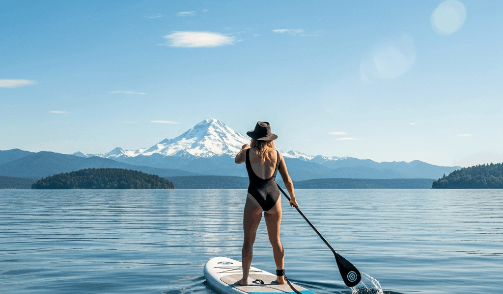
Mount Baker sits at 10,781 feet on the northeastern horizon. On clear days — which Seattle gets more of than its reputation suggests — you can see it from the water. The trick is knowing which routes put Baker directly in your line of sight instead of behind a treeline or blocked by the hills east of the lake.
These three routes are chosen specifically for the Baker view: open water, right direction, minimal obstructions.
Log Boom Park — Kenmore (Best Baker View on Lake Washington)
The north end of Lake Washington gives you the cleanest Mount Baker sightline of any Seattle-area launch. From Log Boom Park in Kenmore, the lake opens northeast and Baker fills the gap between the Cascades perfectly on clear mornings.
Address: 6800 NE 175th St, Kenmore, WA 98028
📍 Get Directions on Google Maps
Parking: Large free lot adjacent to the launch. Almost never a problem to find space — this is an underused gem compared to the Seattle-side launches. Lot opens at 6 AM.
Water conditions: The north end of Lake Washington is exposed to southerly winds that build throughout the day. Morning is calm; afternoons can get choppy. The launch itself is a sandy beach — no ramp, but easy to carry a board in.
The Baker view: Paddle east from the launch toward the center of the lake. On a clear morning, Baker is unmistakable to the northeast. Best light is early morning when the sun is behind you and Baker catches the alpenglow.
Best for: Anyone willing to drive 30 minutes north for uncrowded water and the best Cascade view on the lake.
Juanita Beach Park — Kirkland
On the east side of north Lake Washington, Juanita Beach Park puts you in open water with a clear look at the Cascades and Baker to the northeast. The east shore has a cleaner view angle than the west shore launch points in Seattle proper.
Address: 9703 NE 116th St, Kirkland, WA 98034
📍 Get Directions on Google Maps
Parking: Public lot, free. Can fill on summer weekends — arrive before 9 AM. Street parking on 116th St adds overflow capacity.
Water conditions: Sheltered enough for most conditions. Watch for southerly fetch building whitecaps in the afternoon. The bay just south of the launch offers a shorter, protected paddle if conditions are marginal.
The Baker view: From the water, look northeast. On clear days Baker is visible above the ridge. The open lake between Juanita and the north shore is the clearest sightline on the east side.
Best for: East Side paddlers, families (the beach has lifeguards in summer), anyone wanting a longer north-lake route toward Log Boom Park.
Shilshole Bay — North Puget Sound
For a Puget Sound perspective on Baker, Shilshole Bay launches you into open saltwater north of the Ballard Locks. Paddle north from the marina and on clear days you will see Baker rising above the landscape to the northeast — a different sightline than the lake routes, with the sound’s blue water in the foreground.
Address: Shilshole Bay Marina, 7001 Seaview Ave NW, Seattle, WA 98117
📍 Get Directions on Google Maps
Parking: Large marina parking lot, free for day use. The lot runs along the waterfront and rarely fills on non-peak days.
Water conditions: This is Puget Sound — conditions change fast. Check the NOAA forecast before launching. Afternoon northerlies can create real chop. Tidal currents run north-south along the shore. Not the right choice for beginners or on unsettled days.
The Baker view: Head north from the marina, past Golden Gardens beach. In the open sound, look northeast across the water for Baker. The saltwater foreground and mountain backdrop make this the most photogenic of the three routes on clear days.
Best for: Intermediate and advanced paddlers comfortable with open water and tidal conditions. Also good for anyone doing the Puget Sound coastal route south toward Alki.
Planning Your Baker Day
- Best months for clear views: October through February — counterintuitively, fall and winter produce more clear days than summer, which runs marine layer through July
- Morning launch: Haze builds through the day; Baker is sharpest at 7-9 AM on clear mornings
- Forecast check: NOAA’s Puget Sound marine forecast (weather.gov) gives wind and wave predictions. For lake routes, check Weather Underground’s hourly wind data for the specific launch point
- Camera tip: Baker photographs best from the water with a long lens — the distance compresses and makes the peak look massive above the waterline

Stay in the loop
Get the latest seattle paddleboard updates delivered to your inbox.